
Image Credit: NOAA
More Guest Blogs


From blooming flowers to twittering birds, the signs of spring are popping up and the miseries of winter are becoming a distant memory for many.
But not for some climate scientists.
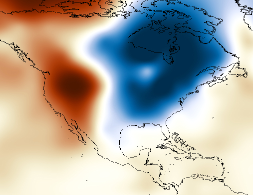
The curiosity of a growing group of researchers has been piqued by the tenacious temperature divide that has separated East from West over the past two winters as a wild zigzag of the jet stream has brought repeated bouts of Arctic air and snow to the East and kept the drought-plagued West baking under a record-breaking dome of heat.
That persistent “warm west, cold east” winter pattern has set off a flurry of research aimed at uncovering why those regions of the U.S. spent winter locked in polar opposite situations, with plenty of questions remaining — including how global warming might be influencing whatever set the atmospheric pattern in motion.
New studies raise new possibilities
The climate shifts of the Pacific Ocean have been considered a primary suspect in driving the seemingly unbreakable divide, in part because many of these have a clear influence on U.S. weather. But two recent studies have pushed past these well-known climate cycles and brought attention to some other, perhaps underappreciated players, in both the Pacific and the Arctic.
In one study, Dennis Hartmann, an atmospheric scientist at the University of Washington, pinpointed a climate cycle that seems to be linked to the most well-known of such phenomena, El Niño. This “new” cycle — which Hartmann calls the North Pacific Mode (NPM) — has been hinted at before, but hasn’t received as much scientific attention as its cousin.
Like El Niño, the NPM features changes in ocean temperatures that then alter the circulation of the atmosphere, including over the U.S. The latter is marked by a pool of warm water in the tropical Pacific that sets off a domino effect in the atmosphere that shifts the jet stream around over the U.S.
Similarly, the NPM features an area of raised ocean temperatures, but this time in a horseshoe pattern that reaches from the tropics, past the West Coast and into the North Pacific. Historical temperature records that Hartmann examined suggest that it also precedes an El Niño event.
Both the warm water signature and a burgeoning El Niño were present over the past couple of years in the Pacific.
Most importantly, the temperature records also show that the NPM matches up with the “warm West, cold East” divide that governed the last two winters. Specifically, it seems to historically coincide with a high pressure ridge over the West and a trough over the East.
Computer modeling backs up the connection
But their simultaneous appearance doesn’t prove the NPM caused the weather divide. To see if that could be the case, Hartmann used climate models, where he could plug in the warm sea surface temperatures and see if the East-West pattern followed. In his simulations, it did.
Hartmann’s study, published online in the journal Geophysical Research Letters, provides “compelling evidence” for a link between the Pacific Ocean temperature signature and the stuck weather pattern, said John Walsh, an atmospheric scientist at the International Arctic Research Center at the University of Alaska Fairbanks, who wasn’t involved in the studies.
But is that the whole story? The other recent study suggests that the Arctic, too, could be playing a role in making the difference between East and West so stark.
Arctic sea loss also plays a role
That study, also detailed in Geophysical Research Letters, suggests that while the Pacific heat set the atmospheric pattern in motion, Arctic sea ice loss in a particular region made the warm/cold difference so extreme, said Jennifer Francis of Rutgers University.
Francis, who wasn’t involved with either study, is one of the main proponents of an idea that by altering how much heat the ocean lets out, sea ice melt and Arctic warming can also change atmospheric circulation patterns, in particular by making the jet stream form larger peaks, or highs, and troughs, or lows. Hence the more intense difference between East and West the last two winters.
However, not all scientists are convinced by this idea and it has generated much debate in recent years.
One key question Hartmann is keen on better understanding is how the overall warming of the planet might impact the climate cycles that potentially put the divide in place. In the historical records, he noticed that the NPM has been more prevalent since the 1970s — about the same time that the global temperature rise really took off. That raises the question of whether this pattern might become a more common influence on U.S. weather in the future.
It’s a difficult question to answer, though, because climate models “are not in agreement on what should happen in the Pacific as a consequence of global warming,” Hartmann said.
Given the terrible drought and dismal snowpack the warm Western winter has resulted in, “it would be likely a hugely bad thing if the global warming response was to give us more of this” East-West divided pattern, he said.
Andrea Thompson is a senior science writer at Climate Central, where this post originally appeared. Thompson focuses on extreme weather and climate change.
Weekly Newsletter
Get building science and energy efficiency advice, plus special offers, in your inbox.


0 Comments
Log in or create an account to post a comment.
Sign up Log in