
More Guest Blogs


This post was written by Emily Schlickman, Brett Milligan, and Stephen Wheeler.
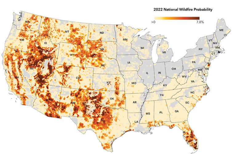
Wildfires are getting larger, more frequent and more severe in many areas. Although efforts are underway to create fire-adapted communities, it’s important to realize that we cannot simply design our way out of wildfire–some communities will need to begin planning a retreat.
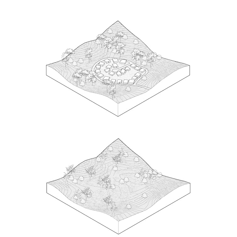
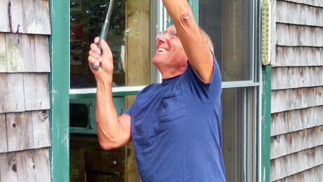
Paradise, California, is an example. For decades, this community has worked to reduce dry grasses, brush, and forest overgrowth in the surrounding wildlands that could burn. It built firebreaks to prevent fires from spreading, and promoted defensible space around homes.
But in 2018, these efforts were not enough. The Camp Fire started from wind-damaged power lines, swept up the ravine and destroyed over 18,800 structures. Eighty-five people died.
Across the American West and in other fire-risk countries, thousands of communities like Paradise are at risk. Many, if not most, are in the wildland-urban interface, a zone between undeveloped land and urban areas where both wildfires and unchecked growth are common. From 1990 to 2010, new housing in the wildland-urban interface in the continental U.S. grew by 41%.
Whether in the form of large, master-planned communities or incremental, house-by-house construction, developers have been placing new homes in danger zones.
It has been nearly four years since the Camp Fire, but the population of Paradise is now less than 30% of what it once was. This makes Paradise one of the first documented cases of voluntary retreat in the face of wildfire risk. And while the notion of wildfire retreat is controversial, politically fraught, and not yet endorsed by the general public, as experts in urban planning and environmental design, we believe the necessity for retreat will become increasingly unavoidable.
But retreat isn’t only about wholesale moving. Here are four forms of retreat being used to keep people out of harm’s way.
Limiting future development
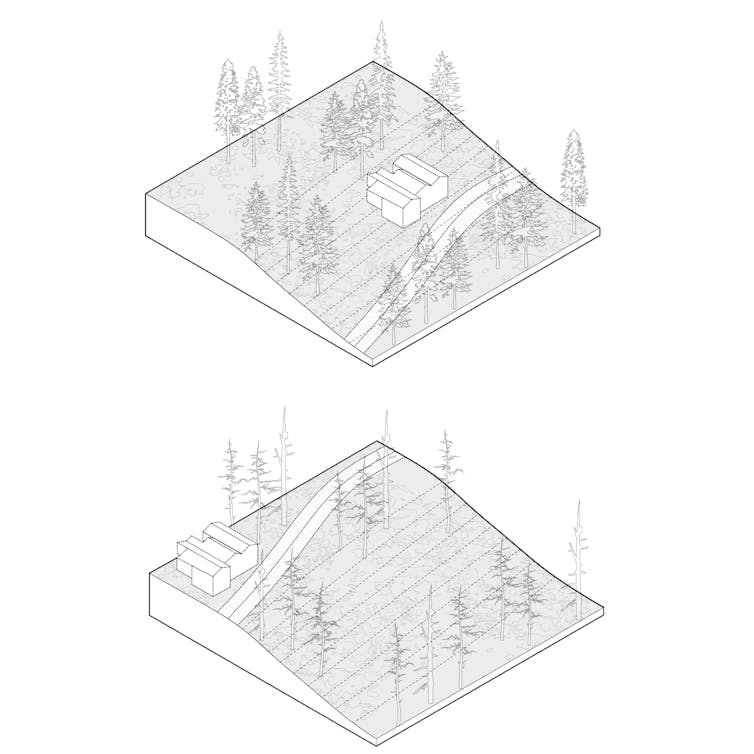
On one end of the wildfire retreat spectrum are development-limiting policies that create stricter standards for new construction. These might be employed in moderate-risk areas or communities disinclined to change.
An example is San Diego’s steep hillside guidelines that restrict construction in areas with significant grade change, as wildfires burn faster uphill. In the guidelines, steep hillsides have a gradient of at least 25% and a vertical elevation of at least 50 feet. In most cases, new buildings cannot encroach into this zone and must be located at least 30 feet from the hillside.
While development-limiting policies like this prevent new construction in some of the most hazardous conditions, they often cannot eliminate fire risk.
Halting new construction
Further along the spectrum are construction-halting measures, which prevent new construction to manage growth in high-risk parts of the wildland-urban interface.
These first two levels of action could both be implemented using basic urban planning tools, starting with county and city general plans and zoning, and subdivision ordinances. For example, Los Angeles County recently updated its general plan to limit new sprawl in wildfire hazard zones. Urban growth boundaries could also be adopted locally, as many suburban communities north of San Francisco have done, or could be mandated by states, as Oregon did in 1973.
To assist the process, states and the federal government could designate fire-risk areas, similar to Federal Emergency Management Agency flood maps. California already designates zones with three levels of fire risk: moderate, high, and very high.
They could also develop fire-prone landscape zoning acts, similar to legislation that has helped limit new development along coasts, on wetlands and along earthquake faults.
Incentives for local governments to adopt these frameworks could be provided through planning and technical assistance grants or preference for infrastructure funding. At the same time, states or federal agencies could refuse funding for local authorities that enable development in severe-risk areas.
In some cases, state officials might turn to the courts to stop county-approved projects to prevent loss of life and property and reduce the costs that taxpayers might pay to maintain and protect at-risk properties.
Three high-profile projects in California’s wildland-urban interface have been stopped in the courts because their environmental impact reports fail to adequately address the increased wildfire risk that the projects create. (Full disclosure: For a short time in 2018, one of us, Emily Schlickman, worked as a design consultant on one of these–an experience that inspired this article.)
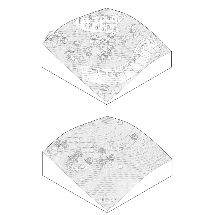
Incentives to encourage people to relocate
In severe risk areas, the technique of “incentivized relocating” could be tested to help people move out of wildfire’s way through programs such as voluntary buyouts. Similar programs have been used after floods.
Local governments would work with FEMA to offer eligible homeowners the pre-disaster value of their home in exchange for not rebuilding. To date, this type of federally backed buyout program has yet to be implemented for wildfire areas, but some vulnerable communities have developed their own.
The city of Paradise created a buyout program funded with nonprofit grant money and donations. However, only 300 acres of patchworked parcels have been acquired, suggesting that stronger incentives and more funding may be required.
Removing government-backed fire insurance plans or instituting variable fire insurance rates based on risk could also encourage people to avoid high-risk areas.
Another potential tool is a “transferable development rights” framework. Under such a framework, developers wishing to build more intensively in lower-risk town centers could purchase development rights from landowners in rural areas where fire-prone land is to be preserved or returned to unbuilt status. The rural landowners are thus compensated for the lost use of their property. These frameworks have been used for growth management purposes in Montgomery County, Maryland, and in Massachusetts and Colorado.
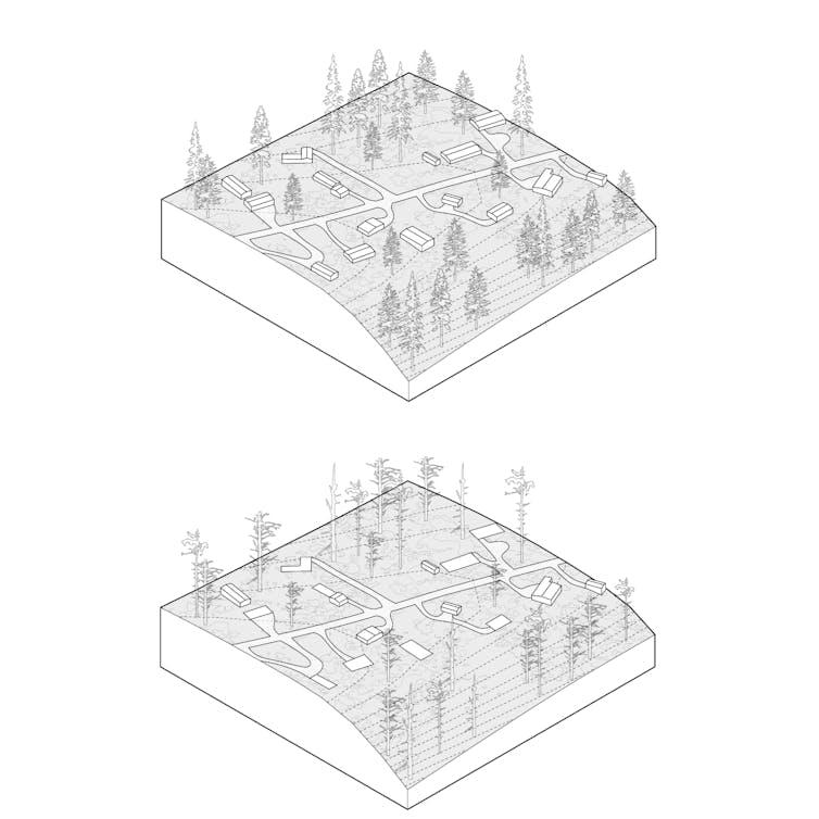
Moving entire communities, wholesale
Vulnerable communities may want to relocate but don’t want to leave neighbors and friends. “Wholesale moving” involves managing the entire resettlement of a vulnerable community.
While this technique has yet to be implemented for wildfire-prone areas, there is a long history of its use after catastrophic floods. One place it is currently being used is Isle de Jean Charles, Louisiana, which has lost 98% of its landmass since 1955 because of erosion and sea level rise. In 2016, the community received a federal grant to plan a retreat to higher ground, including the design of a new community center 40 miles north and upland of the island.
This technique, though, has drawbacks–from the complicated logistics and support needed to move an entire community to the time frame needed to develop a resettlement plan to potentially overloading existing communities with those displaced.
Even with ideal landscape management, wildfire risks to communities will continue to increase, and retreat from the wildland-urban interface will become increasingly necessary. The primary question is whether that retreat will be planned, safe and equitable, or delayed, forced and catastrophic.
Emily Schlickman is an assistant professor of landscape architecture and environmental design at the University of California, Davis. Brett Milligan is an associate professor in the same department. Stephen Wheeler is a professor of urban design, planning, and sustainability at UC Davis. This article originally appeared at The Conversation. Illustrations courtesy Emily Schlickman.
Weekly Newsletter
Get building science and energy efficiency advice, plus special offers, in your inbox.


6 Comments
I think this is a valuable article that addresses many pertinent issues. I suppose I live in one such community: Lakeport Ca. While it is not nearly as vulnerable as some communities are, or were, it has some issues. Before the intensification of the drought and increasing temperatures, I thought and many others did also, that it was manageable risk. About 5 years ago we had a fire that made me rethink some of my estimations of the statistical probabilities of catastrophic fire.
Memories fade and I no longer remember the exact year or name of the fire because there's been so many in the county. I do remember that it was one of the largest fires and the one that came the closest to my home, which is in well within Lakeport proper. For days the atmosphere was dark and ominous with the acrid smell of smoke in the air. The fire came within about 3 miles of my home. There was an evacuation order. I ignored it because I had a failsafe retreat in case I became overwhelmed in the process of defending my home. I live a block from the second largest lake In California. If the worst happened, I had my life jacket and could just walk to the lake and jump in. I still think it was a reasonable plan. I'm 69 and do not want to start over with new construction after doing so much work on my present home. If the worst happened and my home was taken from me, I would still be alive and would know I did everything I could to save my home.
In retrospect the thing that saved our town and my own home was being in town and in an area that was very developed and had relatively high density of population to land area. This meant that the local fire department and Cal Fire, the statewide organization that fights fires on areas not part of national forests, could "efficiently" muster their resources to save as many homes as possible. There were many homes on the outskirts of town that were consumed by the fire and I'm sad for those people. Those outlying properties could not be efficiently defended with the limited manpower that even a large organization like Cal Fire possesses.
The situation is not unlike the history of early settlements in an expanding frontier. People would band together in settlements to decrease risks. It still works. I closely watched the progress of the fire and had moments of doubt. In the end Cal Fire along with the Lakeport Fire Department came through and made a huge effort to save Lakeport proper. I'll be forever grateful. What they did wasn't because I lived there. They did it because there were so many people just like me in a relatively small area. You are taking your life and property in your own hands alone when you live squarely in a wildland/urban area that can't be defended.
Things have changed in the last 10 years, long after I moved here. If I knew then what I know now maybe I wouldn't have moved here. But I'm here now and I ain't moving. I can live with the threat because Cal Fire sees enough people in this area to make the effort to defend it. I would be more nervous if I was living on the outskirts of town. A lot more. I'm still nervous but it's manageable.
get a canoe.
What is the source of your domestic water? Do you have access to the water in the nearby lake for firefighting purposes? A high pressure water pump along with some quality firehose will go quite a way in putting out fires. It would not however help much with fire spread in the tree canopy if you have one.
https://powerequipment.honda.com/pumps/high-pressure-pumps
I have a WH15 that I use for controlled burns on grassland in the spring. This is the 1.5 inch pump and it puts out an unbelievable amount of water. Considered the 2" but felt the hose full of water would be too much to drag around, the 1 1/2" is enough of a workout.
Maybe I was being overly optimistic, but I intended to just use my regular water hoses. Our water utility takes water from the lake and sends it to everyone after treatment. So, it would seemingly be an endless supply of water. What seems to be the controlling factor for that to be effective is to make sure your neighbors aren't doing something stupid like putting sprinklers on their roofs. That will just shut down water pressure for everyone.
I'm sure if a fire came with high winds my puny firefighting equipment wouldn't come close to cutting it. But in calm conditions I think it would be enough to tamp down burning embers coming from a fire a mile or so away. That's all I really intended to accomplish. A full conflagration would be outside my capabilities.
It sounds like you are very well equipped.
Left out of the discussion is improving building codes that reduce chances of buildings catching on fire. Simple things such as size of attic ventilation screening that may allow wind driven embers to be blown right into an attic, roofing design that allows hot embers to collect on a roof, using flammable roofing material, flammable siding, etc. etc.
chimewind,
Several jurisdictions have taken the lead on that:
- The International Code Council’s International Wildland Urban Interface Code (IWUIC).
- The National Fire Protection Association’s Standard for Reducing Structure Ignition Hazards from Wildland Fire (Standard 1144).
- The California Building Code Chapter 7A—Materials and Construction Methods for Exterior Wildfire Exposure.
Log in or create an account to post a comment.
Sign up Log in